 |
| We've spent many quiet moments contemplating amazing vistas like this. |
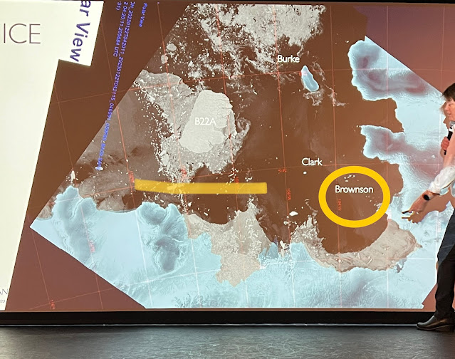 |
| Brownson Islands and our passage around B22A (satellite image) |
A month ago today while on our Antarctic Peninsula and Subantarctic Islands expedition, we sailed alongside A76A a massive iceberg drifting in the Scotia Sea. Then a couple of days ago we passed another mammoth iceberg half its size but still humongous - the fourth largest iceberg in the world, the B22A. This iceberg broke off the Thwaites Ice Tongue which is a huge ice outflow projecting into Pine Island Bay from Thwaites Glacier. Thwaites Glacier is nicknamed the Doomsday Glacier because it is at risk of collapsing. The timing of that can only be estimated from modelling but rising sea temperatures will increase the melt rate of that component of the glacier which projects out beyond the land to which it is bound onto the sea surface. It's so hard to imagine - 3 km thick and the size of Texas draining into Pine Island bay and on out into the Amundsen Sea. I know that many people are alarmed at what will happen to Antarctica with ‘global warming’. It is mainly West or Lesser Antarctica that is at most 'immanent' risk because a considerable amount of that is ice over water. A 2022 assessment of tipping points in the climate system indicated that the entire West Antarctic Ice Sheet would most likely take 2,000 years to disintegrate entirely once it crosses its tipping point, and the minimum timescale they suggest is 500 years. In regard to Thwaites Glacier, scientists are concerned that only part of Thwaites - specifically its Eastern Ice Shelf, the part of its body that floats above the ocean - may collapse within 10 years. Take that in whatever way you can understand it – it baffles me. Many of the icebergs that break off these huge glaciers run aground and refreeze into surrounding ice. Incidentally,
West/Lesser Antarctica joins East/Greater Antarctica at the Transantarctic Mountains which run pretty much from the east side of the Ross Sea (which lies due south from New Zealand) to the Weddell Sea on the opposite side of the continent (confusing I know but the Weddell Sea is that big scooped out bit above the sign for Thwaites Glacier on the pic below - I hope I haven't confused you more!). |
| West/Lesser Antarctica joins East/Greater Antarctica at the Transantarctic Mountains |
 |
| One of the Brownson Islands |
 |
The hikers gathering to walk to the summit of one of Brownson Islands
|
So back to our travels! This afternoon we headed for a place where few tourist vessels venture – the Brownson Islands. This is an important breeding region for penguins and we saw many. Our group of polar hikers landed on one of the islands with the aim of climbing to the top. Rock samples have been taken from the particular island but the rest of the islands in the group have not been well explored. Driving our zodiac is Marilia one of our guides, a marine mammal specialist who was just a powerhouse of enthusiasm. An absolutely delight.
 |
| Have you ever walked on iced rocks - in gumboots ? It's a bit challenging! |
While the hikers were trudging to the top of their island, the rest of us headed for another snow- and ice-covered island. They believe no-one has ever set foot on this island so we were quite excited. The landing spot was rather precarious as it was slippery rocks and ice so everyone needed assistance. I and a number of other passengers stayed on the zodiac and cruised around some of the 20 islands in this group.


No comments:
Post a Comment